


+ 48
Big Daddy Loop
Hiking Trail
Hard
10.94 mi
1,769 ft
A staple hiking loop on Lookout Mountain that extends into Georgia.
Whether you're a local or just visiting, this is one of the best hiking loops Chattanooga has to offer. Just a short drive from downtown, the route traverses historic Lookout Mountain into Georgia and showcases one of the best trails in the region - the Bluff Trail.
Start your hike at Cravens House, the trail enters the forest just behind it. If the gate is closed, there is a secondary lot just below the main one. Most hikers prefer this route counter-clockwise, beginning with a steady traverse on an old road bed to warm up.
After descending Gum Springs Trail, you'll take a left onto Skyuka Trail and gradually descend closer to the valley below. This portion is quite secluded and you'll quickly forget how close to town you are. This section has a rugged, backcountry feel and Skyuka Springs is the perfect opportunity to hydrate before a punishing climb out of the valley. The Bluff Trail lies ahead - an excellent reward for your efforts.
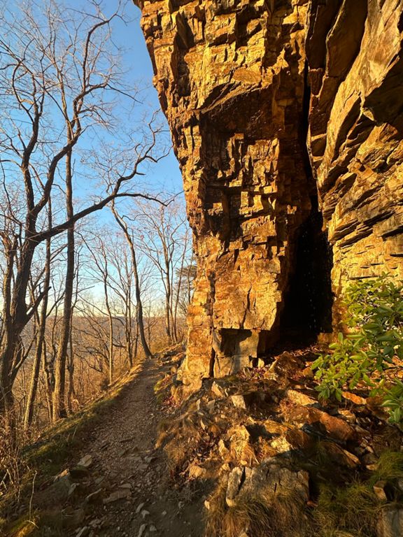
The Bluff Trail parallels the western ridge of the mountain and showcases several massive sandstone cliffs on one side - with incredible views of the valley on the other. Your last stop along this loop is Sunset Rock, a rock outcropping with a phenomenal overlook. Its close proximity to the trailhead makes this an excellent destination for a shorter hike. From there, it's all downhill back to the trailhead.
The official route links the following trails when completed counter-clockwise: Rifle Pits > Guild > Gum Springs > Skyuka > John Smartt > Bluff > Cravens House
Sources:
Written by Brendon Voelker
Whether you're a local or just visiting, this is one of the best hiking loops Chattanooga has to offer. Just a short drive from downtown, the route traverses historic Lookout Mountain into Georgia and showcases one of the best trails in the region - the Bluff Trail.
Start your hike at Cravens House, the trail enters the forest just behind it. If the gate is closed, there is a secondary lot just below the main one. Most hikers prefer this route counter-clockwise, beginning with a steady traverse on an old road bed to warm up.
After descending Gum Springs Trail, you'll take a left onto Skyuka Trail and gradually descend closer to the valley below. This portion is quite secluded and you'll quickly forget how close to town you are. This section has a rugged, backcountry feel and Skyuka Springs is the perfect opportunity to hydrate before a punishing climb out of the valley. The Bluff Trail lies ahead - an excellent reward for your efforts.
The Bluff Trail parallels the western ridge of the mountain and showcases several massive sandstone cliffs on one side - with incredible views of the valley on the other. Your last stop along this loop is Sunset Rock, a rock outcropping with a phenomenal overlook. Its close proximity to the trailhead makes this an excellent destination for a shorter hike. From there, it's all downhill back to the trailhead.
The official route links the following trails when completed counter-clockwise: Rifle Pits > Guild > Gum Springs > Skyuka > John Smartt > Bluff > Cravens House
Sources:
Written by Brendon Voelker
Created By
Strava Routes
