


+ 130
Mount Mansfield Summit from Auto Toll Road
Hiking Trail
Hard
2.4 mi
617 ft
The easiest route to the summit of Mount Mansfield.
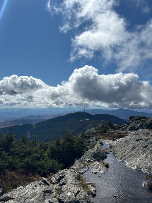
Stowe, Vermont sits at the foot of the tallest mountain in the state–Mount Mansfield at 4,393 feet. On top of the mountain, the extreme climate creates a tundra-like landscape of stunted conifers and windswept rock. It’s a harsh environment, but well worth visiting for the unbeatable views over Vermont’s endless green hills, and for the satisfaction of standing on the state highpoint. That’s why Mount Mansfield is one of the most popular hiking destinations in Vermont. Many trails ascend its slopes and converge on top. The hike described here is the easiest way to the summit, though it’s certainly no “walk in the park.” It is the best route for families with small children or anyone unaccustomed to strenuous hiking. It begins from the Mount Mansfield Visitor Center, which is at the end of the Auto Toll Road in Stowe Mountain Resort. The road is typically open from May to October, weather permitting. The drive itself is beautiful, winding upward through a verdant forest on a ridgeline overlooking the ski resort. The hike follows a section of the Long Trail, which is a footpath traversing the Green Mountains end to end. At first, you’ll dive into a dense forest of squat evergreens, but soon emerge onto bare rock along the spine of the mountain, and the slope becomes steeper. Watch your footing, because the rock is often wet and slippery. Also, take care to stay on the path and not trample the soil or plants that cling to life at this elevation. Following white blazes painted on the rock, the trail moves steadily upward, weaving among boulders and patches of greenery, with huge views in every direction. This is part of Vermont's famous [Long Trail]( footpath that traverses the Green Mountains and spans the state from Massachusetts to Canada. Eventually, you’ll reach the true summit of Mount Mansfield, a dome of bare rock rising higher than anything else around. On a clear day, you can see Burlington, Lake Champlain, and the Adirondacks beyond. On a very clear day, you can see eastward all the way to the White Mountains of New Hampshire. Sources: Written by Jesse Weber
Stowe, Vermont sits at the foot of the tallest mountain in the state–Mount Mansfield at 4,393 feet. On top of the mountain, the extreme climate creates a tundra-like landscape of stunted conifers and windswept rock. It’s a harsh environment, but well worth visiting for the unbeatable views over Vermont’s endless green hills, and for the satisfaction of standing on the state highpoint. That’s why Mount Mansfield is one of the most popular hiking destinations in Vermont. Many trails ascend its slopes and converge on top. The hike described here is the easiest way to the summit, though it’s certainly no “walk in the park.” It is the best route for families with small children or anyone unaccustomed to strenuous hiking. It begins from the Mount Mansfield Visitor Center, which is at the end of the Auto Toll Road in Stowe Mountain Resort. The road is typically open from May to October, weather permitting. The drive itself is beautiful, winding upward through a verdant forest on a ridgeline overlooking the ski resort. The hike follows a section of the Long Trail, which is a footpath traversing the Green Mountains end to end. At first, you’ll dive into a dense forest of squat evergreens, but soon emerge onto bare rock along the spine of the mountain, and the slope becomes steeper. Watch your footing, because the rock is often wet and slippery. Also, take care to stay on the path and not trample the soil or plants that cling to life at this elevation. Following white blazes painted on the rock, the trail moves steadily upward, weaving among boulders and patches of greenery, with huge views in every direction. This is part of Vermont's famous [Long Trail]( footpath that traverses the Green Mountains and spans the state from Massachusetts to Canada. Eventually, you’ll reach the true summit of Mount Mansfield, a dome of bare rock rising higher than anything else around. On a clear day, you can see Burlington, Lake Champlain, and the Adirondacks beyond. On a very clear day, you can see eastward all the way to the White Mountains of New Hampshire. Sources: Written by Jesse Weber
Created By
Strava Routes
