

+ 124
Yosemite Falls Trail
Hiking Trail
Hard
6.23 mi
3,183 ft
Steep hike to the top of North America's tallest waterfall.
Yosemite Valley is home to numerous waterfalls, but the one that shares the valley’s name might be its most impressive. Yosemite Falls, a series of three cascades that are collectively 2,425 feet tall, is North America’s tallest waterfall. Because they are so tall, and because the middle section is recessed into the cliff, it is impossible to see the whole thing in one view. The best way to experience the entire waterfall is to hike the Yosemite Falls Trail to the very top. This is a strenuous hike with many switchbacks, but it is the only way to reach the view at the lip of Upper Yosemite Fall. From there you can look straight down at its 1400-foot freefall and the middle cascades, plus a commanding view over the valley.
The best time to see Yosemite Falls are April through early July, when the creek is at its highest flows. The falls typically dry up sometime in August after the snow has all melted from the high country. Large rain storms can bring them back for a day or two, but continual flow does not resume until snow returns in winter.
Beginning from the Valley Loop Trail, Yosemite Falls Trail punches uphill immediately. After climbing 1,000 feet in the first mile, you’ll reach a spectacular viewpoint at Columbia Rock. From there you can see Half Dome and an elevated perspective on the valley. Continue half a mile more on easier terrain to a view of Upper Yosemite Fall. This makes a good turnaround point for those not interested in the more strenuous second half of the climb.
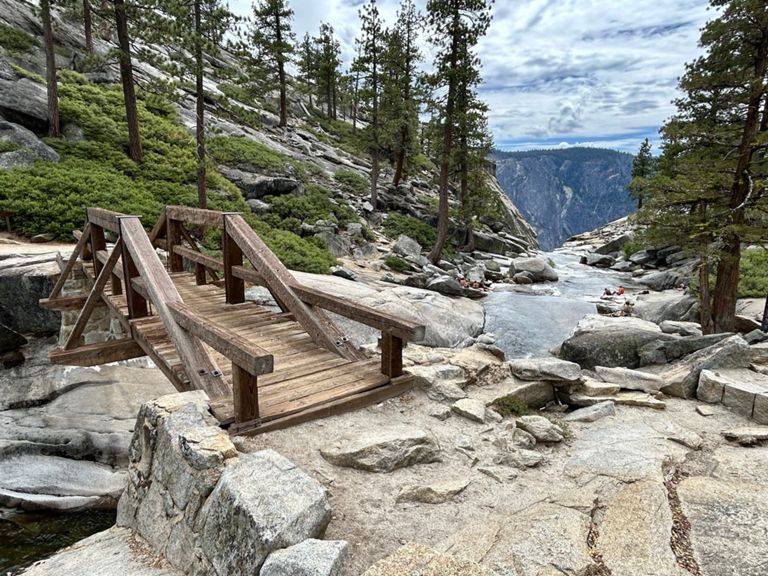
If you complete it, you will be rewarded with cliff-top views above the waterfall. Near the top, the trail meets Yosemite Creek, which tumbles listlessly through pools in granite before suddenly plummeting off the cliff. At the cliff’s edge, a handrail protects hikers along the trail, but if you leave the trail you must beware of slick rock and drop-offs. The whole trail is open year-round, but the upper part is not recommended in winter because snow and ice add to the difficulty and danger.
Sources:
Written by Jesse Weber
Route and Elevation
Segments
| Name | Distance | Elev. Diff. | Avg. Grade |
|---|---|---|---|
| Columbia Rock | 1.06 mi | 1,040 ft | 18.5% |
| Yosemite falls trail junction to trail junction climb | 2.80 mi | 2,605 ft | 17.5% |
| Upper yosemite waterfalls | 1.58 mi | 1,201 ft | 13.5% |
| Yosemite Falls (Trailhead to First View) | 1.28 mi | 1,207 ft | 16.1% |
| Yosemite Falls | 3.07 mi | 2,592 ft | 16.0% |
| Camp 4 Parking Climb | 0.40 mi | 184 ft | 8.6% |
| Lower Yosemite Fall Trail Climb | 0.51 mi | 666 ft | 24.3% |
| Lower Yosemite Fall Trail Climb | 0.09 mi | 486 ft | 92.8% |
| Lower Yosemite Fall Trail Climb | 0.33 mi | 394 ft | 20.3% |
| Lower Yosemite Fall Trail Climb | 0.44 mi | 262 ft | 11.3% |
| Yosemite Falls Descent | 3.18 mi | -2,484 ft | -14.6% |
| Yosemite Fall Down | 1.00 mi | -1,644 ft | -30.7% |
| Lower Yosemite Fall Trail Climb | 0.45 mi | 308 ft | 11.7% |
| Hiking Trail Climb | 0.24 mi | 82 ft | 6.3% |